
May 5 - Sea to Sky Snow Conditions

Overall theme:
Melt-down coming to an end? Freezing levels are dropping and we’ll see some overnight freezing happening but the loss of snow has been happening fast!
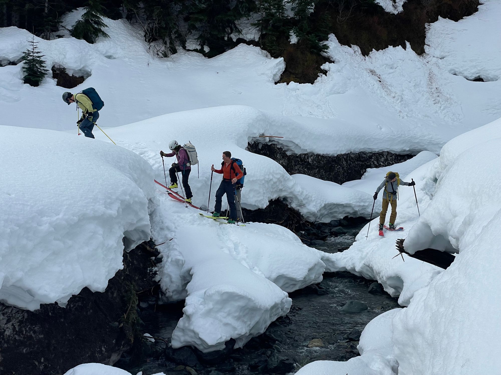
Where we’ve been skiing:
Eric has skied a few times around Squamish and Whistler while Evan was down at Mt. Baker. Throughout the corridor, we’re seeing an isothermal snowpack - meaning it’s has melted and transformed almost entirely through! Access to Mt. Baker is still complicated by the washout on the Heliotrope Ridge road. The South side is accessible as normal. Mt. Rainier has seen ski descents via various routes as well.
Bergshrunds, moats, and crevasses are opening up fast. We’ve also seen some ski lines have fallen down entirely. Check out this crazy photo of Disease Ridge!
What’s happened since the last update (weather & general snowpack structure):
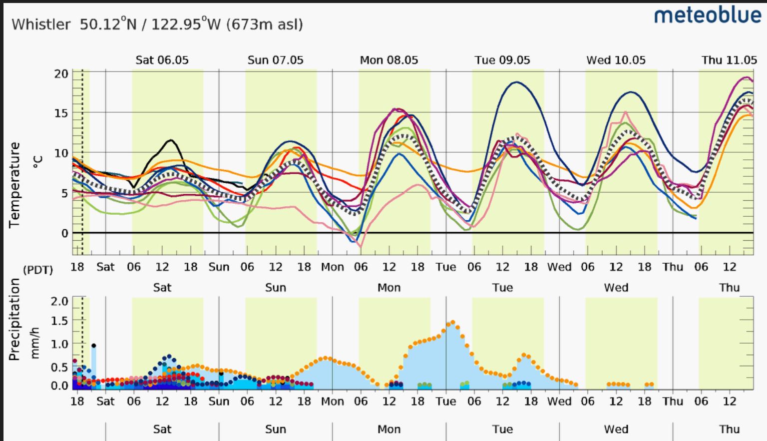
This week has of course been characterized by high freezing levels and a bit of precipitation (but mostly strong sun). This has gone a long way towards settling the snowpack, making it dense and isothermal. This extends down into the mid-pack with pole penetration almost 1 meter at tree line! This means heat and liquid water are hitting the base of the snowpack -something that has caused big avalanches! It’s unclear if this has completely permeated the deep persistent weak layers that has resulted in these big avalanches but it’s probably safe to assume it’s still possible. We’ve seen daytime highs of 20C on the Duffey Lake Road and multiple days with the freezing level NOT dipping below Whistler Peak. This means we’ve had a major loss of snowpack height overall.

What’s the weather and avalanche forecast?
Friday brought a change in the weather pattern with a low pressure system bringing colder temps and precip throughout the corridor. This should end with the passage of a cold front that will bring FLs to an even lower elevation on Friday afternoon. Avalanche hazard remains elevated with both wet loose and deep persistent slab problems. It’s also important to note that today is the final day of AvCan forecasts.
What are my questions for the weekend?
How much snow on Friday night/Sat? So far it doesn’t look like much! Most of Friday’s precip fell as rain. If things cool off and precip continues, we may see a little bit of fresh snow, especially in the high peaks.
How well is the new snow bonding to the melt-freeze surface? If the surface was pretty wet when the new snow started falling, it should be a good bond. If the surface freezes hard before the precip, it may not bond as well. The new snow will also insulate the old surfaces and prevent a good refreeze for a few days, so even though the surface might feel ok, the same depth/quality of isothermal will exist for longer than hoped for if it snows a significant amount. Remember no elevation band has been spared from the dramatic warming!
Will we see clearing on the weekend that allows us to get up high? For the moment, it looks like early next week will have the best chance for a combination of cold temps and clearing weather but that remains to be seen!
What will I watch out for or avoid completely?
We’ll probably not be skiing tight couloirs. North facing terrain will be pretty smashed up by the warming. It’s unlikely to recover quickly. South facing terrain will be more promising for corn skiing and rough surfaces to melt down a bit.
I’ll be watching out for newly uncovered features with lots of snow loss - more rock!

Closing Thoughts:
The snowline is moving upwards - access is going to get trickier. We’re getting into the season for the committed folks… and big high peaks! We’ll be keeping an eye on the Cascade volcanos for when the freezing levels are reasonable and high pressure makes for good visibility. Runnels will be a thing in steep terrain - cornices and avalanches bomb down couloirs and these runnels freeze solid. Old debris will be an issue as well in runouts, especially on north aspects where it doesn’t get as much snow. Cornices at least have been dropping and are probably a little less scary but they’re still around.
Eric Carter and Evan Stevens contributed to this report. For more information, check out Zenith Mountain Guides and our local avalanche forecast. This update is supported by SkiUphill Squamish - the best stop for ski touring equipment in the Coast Mountains!
Use this information at your own risk! We are not responsible for your actions in the backcountry and things change rapidly from when this report was written!

Member discussion